Everything Has Been Taken Over and Turned Into Something Else
The SlackWater Center at St. Mary’s College of Maryland is a consortium of students, faculty, and community members documenting and interpreting the region’s changing landscapes. Oral histories are at the core of the center, which encourages students to explore the region through historical documents, images, literature, and scientific and environmental evidence. Some of this work is published in the print journal SlackWater, some of which is online and some published here. The work below was first published in spring 2009.

Everything Has Been Taken Over and Turned Into Something Else
By Anne Dowling Grulich
I worked with the attorney general’s office about five years acquiring land for the state, mostly the roads, and you know taking people’s land is an emotional thing. It’s not just dollars and cents. “You have taken my land which I didn’t want to get rid of,” and it really does get bitter at times.
– Judge Joseph Mattingly, 1967
In 1954, after 14 years of marriage, two children, and a decade-and-a-half of tenant farming, Stephen and Edith Bean finally bought their own land. They bought 48 acres of farm land complete with a two-story farmhouse and several barns near the corner of Route 5 and Rosecroft Road in St. Mary’s City for $14,250. The Beans were finally “home,” permanently anchored to land of their own. But as the 1960s dawned, they soon felt their very own land shift beneath them. Their property was one of many that would become part of the 835 acres of a Maryland archaeological preserve in the National Historic Landmark now known as Historic St. Mary’s City.
This wasn’t the first time the landscape had shifted beneath the Beans’ feet. Three times before they had been forced to move as St. Mary’s County welcomed more and more economic development. In the 1940s, Stephen and Edith worked as tenant farmers in the Villa area near Beachville, south of St. Mary’s City, until the Navy’s Webster Field base was built. From Beachville, the Beans moved to farm land in Jarboesville. “You ever heard of Jarnboesville?” the Beans’ daughter, Frances Bean Titus, asked her interviewer, Andrew Bove, in 2007. “It was where the Navy base is now [in Lexington Park].” On they moved from Jarboesville to Drayden to farm there until their land became the Harry Lundeberg School of Seamanship.
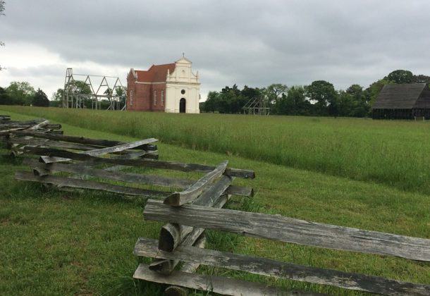
 “So every place they have lived has been taken over, so to speak, by something, and turned into something else,” recalled Frances. That’s why owning the land in St. Mary’s City was especially dear. They finally owned land that would feed and clothe their family, land that could be passed down to their children and their grandchildren. “Everything came from the land … came from the ground. We never wanted for anything … the only income that our parents had was from the land, from the crops … That’s how we were brought up. From the land.” Under agreement with the St. Mary’s City Commission, the Beans farmed just about all the land in St. Mary’s City – the fields of tobacco, wheat, corn, and barley ran along Rosecroft Road to the river bluff, along Route 5 where the reconstructed 17th-century chapel now stands, and all the way down to Chancellor’s Point.
As a little girl in the ’60s, Frances recalled Rupert Lore’s big black car pulling up to their two-story farmhouse. Lore told her father all about how the county was growing and what Williamsburg-like plans the St. Mary’s City Commission had for the farmlands. And Frances remembered how her mother would get real nervous every time Lore pulled into their driveway. In 1966, Mr. Lore offered her father a thousand dollars an acre. “In the mid-’60s that was a lot of money – a lot. My father only paid about fourteen thousand dollars for 48 acres in ’54.” The Beans sold the land to Lore, but kept four acres along Rosecroft Road where Edith’s brother built them a new brick house. Not long after that, Lore sold the property to the St. Mary’s City Commission, and the Beans’ old two-story farmhouse on Route 5 was torn down. “I wish they had the opportunity or felt like they could have said, “No, I’m not going to sell this piece of property because I want to keep it for my family.” But for whatever reason, they didn’t,” recalled Frances with the heavy heart of a middle-aged mother who now comprehends the dilemmas her parents faced.
In 1994, the St. Mary’s City Commission purchased the Beans’ brick home on Rosecroft Road and its four surrounding acres with an agreement of life tenancy for the elderly Beans. Frances recalled two gentlemen and a woman from the Maryland State Highway Administration sitting at the dining room table with her parents that day. “And the lady comes in with one of those huge legal-sized checkbooks. She literally wrote out the check right in front of them … I think my father was very disappointed that not one person from the St. Mary’s City Commission came that day. I mean here he is giving his property to the Commission and none of them came! I found that very strange. He found that very strange. My mother found that very strange.”
Since then, these once productive, vibrant farmlands have, for the most part, been preserved intact circa 1970s, not so much for the beauty of the landscape, but for the archaeological remains of Maryland’s 17th-century capital that lie undisturbed, save by the plow, below ground. It is hard to see the plug pulled on your neighborhood, to have it become a set or backdrop for another seemingly more important story. Suddenly your childhood is a ghost town. Visitors pay to learn about the lives that went on hundreds of years before yours while your own story is dismantled. “I come by these homes every single morning when I go to work, and I still remember what they looked like when the families owned them … That’s where the Peacocks lived, that’s where the Milburns lived … the Duerfeldts, Marleys, Hogabooms, Branhams, Scheibles. The Genevieve Brown house on the corner of Rosecroft and Route 5 was a general store.”
While many people salute the preservation of the past and the rich history that is told by the artifacts in the ground, and many others applaud the lack of development along the waterfront, there are still those who long for the way it used to be. The not-so-distant, not-yet-antique or not-yet-sacred past is etched in living memory and remains extant in remnants on the landscape. A barn. The trace of a driveway. Houses unattended. Family names. The past is so tantalizingly close it’s nearly tangible in conversations and photo albums. The ‘60s were by no means the beginning of change for the St. Mary’s County landscape, but for some families it was a watershed.