MyCoast Data Shows Impact of January Flooding in MD
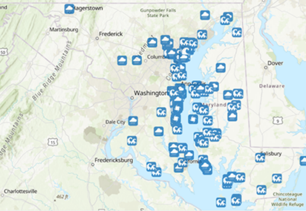
(Map courtesy of MyCoast, Maryland Department of Natural Resources)
On January 9, Maryland was hit by a storm that brought intense rain, strong winds, and high tides.
It resulted in the most active week yet for the Maryland Department of Natural Resources’ MyCoast MD app. The app allows users to submit reports and photos of flooding, as well as other environmental information.
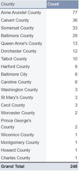
The storm brought in about 400 new users for MyCoast, along with 248 reports of flooding.
Reports came largely from the counties along the Chesapeake Bay, with 77 reports from Anne Arundel County, 36 from Calvert County, and 33 from Somerset County.
Most reports indicated high tide flooding, though others reported storms or coastal damage.
The flooding broke multiple records.
 National Oceanic and Atmospheric Administration tide gauges recorded the highest ever crests in Havre de Grace since the gauge was installed in 2012, as well as crests that reached the top five in Baltimore, Solomons Island, and Chesapeake City. Annapolis saw a high tide of 5 feet, one of the highest on record for the city.
The coastal zone of Maryland was under a flood warning for multiple days.
The storm dropped more than 2 inches of rain in some areas of the state – a considerable total when most counties see an average of about 3 inches of rain during the entire month of January.
With these conditions, municipalities benefit from receiving as much information as possible about flooding and areas of concern.
Officials have pointed to MyCoast as a tool that can fill in the blanks for flood response, showing how and where infrastructure is affected by flooding.
This article was written by Kate Vogel, coastal resilience planner with the Maryland Department of Natural Resources.