Navy Plans Webster Field Tower Project
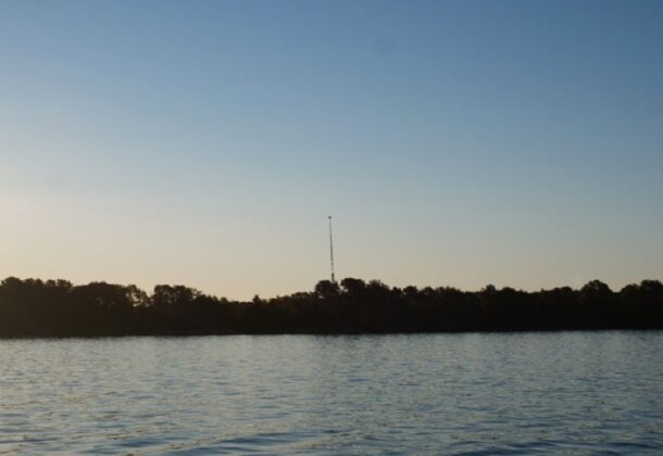
The view of Webster Field Tower Site 4 from Rosecroft. (US Navy photo)
The Department of the Navy is proposing CUJO Towers at Naval Air Station Patuxent River’s Webster Field.
DoN released on January 18, 2022, this required notice of the proposed towers and the effect of its activities on historic properties. It is required for Section 106 consultation, per the National Historic Preservation Act of 1966.
CUJO is a test and evaluation project that integrates test equipment designed to tune Counter Unmanned Aircraft System (UAS) used for base defense against threat Unmanned Aircraft Vehicles (UAV). The project will be erecting six trailered telescoping towers on the Webster field complex. The telescoping towers can be erected up to 150 feet in height. The towers themselves appear to be more similar to large antennae masts rather than actual buildings. They are aluminum structures with open lattice webbing, with a gray color of oxidized aluminum.
Each tower is stabilized by nine 3/8-inch guy lines tied into three 18,000-pound ballast weights. The towers are also equipped with lighting to ensure aircraft can see them day or night. In the Navy’s current concept of operation, the towers will be lowered if/when there is a named storm planned for the area.
Area of Potential Effect on the Ground
The towers will have a small footprint on the ground. However, given the high density of archaeological deposits at Webster Field, Tower Site 4 may impact archaeological site 18ST432, and Tower Site 5 will impact archaeological site 18ST87.
Archaeological testing is underway to gauge the effects of the project on these resources. Sites 1, 2, and 3 have been successfully sited away from archaeological resources.
Identified Historic Properties
The DoN is concerned about visual impacts of the new tower on the view shed of historic properties along St. Inigoes Creek. Cross Manor is adjacent to the Coast Guard facility along the creek, and Rosecroft is situated on the point north of St. Inigoes Creek. In addition, Historic St. Mary’s City lies along the northern shore of the creek.
In order to estimate the visual effect, the Navy flew drones to the height of the proposed tower, then photo-shopped an estimated appearance of the tower onto an image taken from the water adjacent to the historic properties. While this may not give the most precise model of the tower, it does give us a realistic estimate of the impacts.
Close to the main gate, the St. Ignatius Church could be visually affected by a tower. Currently, several trees would shield its viewshed from the tower. The Navy is proposing to plant additional trees in order to maintain the buffer in the future.
The Navy is interested in conducting a public meeting through Zoom if there is interest. If members of the public have any questions or concerns, email Craig Lukezic, cultural resources program manager, at [email protected].