A Park History Timeline
 1790 – 1878 – farmland lines the southwest shore of Patuxent River’s mouth into the Chesapeake Bay. The area at the crossroads of Three Notch Road and Great Mills Road is known as Centerville
1878 -Centerville is renamed Jarboesville upon establishment of post office by first postmaster, Jefferson B. Jarboe.
1901 – Pearson Post Office commences at Great Mills Road and Three Notch Road among a cluster of roadside commerce including Hiram Millison’s store and bar, the Community Building and Bell Motor Company.
1932 – Jarboesville Post Office closes permanently, mail sent to Hermanville.
1941-1942 – U.S. Navy condemns 6,400 acres along this shore westward to Three Notch Road from Great Mills Road to Hermanville Road. The housing shortage reaches crisis proportions.
1942 – U.S. Navy hires renown architect and builder to construct Lexington Park – a 350-home community of tri- and duplexes completed in 1943. The community is named Lexington Park but is almost immediately and ever since known as The Flattops.
1943 – Federal Housing Authority oversees construction of Carver Heights (125 homes and 71 dormitory spots for African Americans who do not approach this capacity. FHA refuses to admit whites. Demolished and replaced with the Southhampton duplex-housing in the 1970s.
1944 – Millison Plaza is built and includes food stores, a variety store, a drug store, a barber shop, a beauty parlor, valet shop, bank and ultimately Lexington Park Post Office.
 1944 – Cedar Park Trailer Camp with ultimately 200 trailers and 150 trailer spaces made available at the northwest corner of Three Notch Road and Great Mills Road.
1944 – Frank Knox School built by the Bureau of Aeronautics for children of military personnel and deeded to the county in 1953.
1946 – Pearson Post Office moves to community building at Tulagi Place. Replaced by Lexington Park Post Office in 1947 at the same address before moving to Millison Plaza property.
1947 – Patuxent Park was begun on 216 acres along Great Mills Road.
1950 – 1960s – Town Creek subdivision built off Three Notch Road
1953 – Lexington Park Elementary School built.
1953 – Safeway food store opened on Shangri La Drive and later relocated to Great Mills Road at South Essex Drive. (Closed in the early 1990s; currently office space.)
1958 – Carver Heights, an elementary-high school originally built for African American students, expanded in 1960, transitioned to a middle school in 1967 when St. Mary’s County public schools integrated and returned to use as an elementary school simply named Carver Elementary School in 1974.
1962 – The Flattops are sold to a private land management firm.
The community building located next to the current Three Notch Theatre continued in public use as a library, post office, sheriff’s headquarters, branch office of the St. Mary’s County Board of Education and a St. Mary’s County Recreation and Parks programming space until razed in the late 1980s.
The Navy dormitory built on Coral Place converted into the Lexington Park Hotel , a movie theater named Park Theater and a row of small shops. This bank of buildings was condemned in the late 1980s and razed in the 1990s.
Mid 1960s – 1970s – South Essex subdivision built.
1966 – survey determines need for county airport leading to acquisition in 1968 of property north of St. Andrews Church Road off Three Notch Road. Airport remains within the Lexington Park Development District boundaries.
 1966 – St. Mary’s County Planning Commission completes General Development Plan for the Central Business District of Lexington Park, Maryland. The plan projects commercial development into 1985.
1968 – Queen Anne Apartments built on Great Mills Road.
1978 – St. Mary’s County completes its first Comprehensive land-use plan and identifies an Urban Development District covering Lexington Park and Leonardtown west of Three Notch Road.
1988 – First update to the Comprehensive Plan severs the Lexington Park Development District from Leonardtown with a swath of rural zoning. The boundaries are inexact in this plan, but LPDD extends west of Indian Bridge Road and east of Three Notch Road. A small rural strip again separates LPDD from Hollywood although the boundary includes the county airport and the industrial park to its north.
1991 – Patuxent River Naval Air Station slated to expand following Base Realignment Consolidation. Again in 2001 Pax NAS expands resulting from realignment of naval aviation activities.
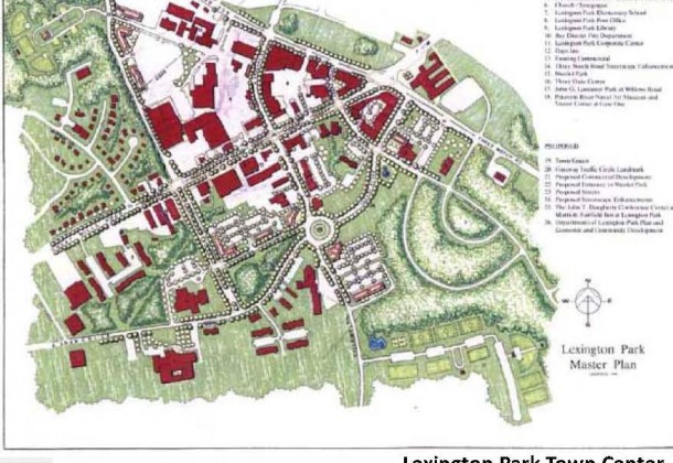
 1994 – Lexington Park master plan launched by a county-hired consulting firm to address population boom and is completed in 1995. Citizens, property owners and the U.S. Navy are actively involved. The plan concentrates on the area depicted in the 1966 Central Business District map. The plan is adopted in 1999.
1995 – Construction begun of McKays store at Great Mills Road and Westbury Blvd.
1999 – Update to the Comprehensive Plan excludes area west of Indian Bridge Road from LPDD.
2004 – St. Mary’s County acquires the Flattops and in 2005 gives management of the property to the Community Development Corporation.
2005 – A comprehensive plan is written for the entire LPDD the boundaries roughly corresponding with those of the 8th District — clearly including California and Great Mills Zip codes. The 1999 Lexington Park master plan is incorporated.
2011 – LPDD update is launched by a county-hired consulting firm to engage property owners, citizens and county officials in process.
Stories: