MD Rt 4 Bridge Alternatives Presented April 22
Since the last public meeting in 2010, the Maryland State Highway Administration (SHA) has honed alternatives for the MD 4 Thomas Johnson Bridge project to the need for at least four lanes.
An informational meeting on the MD Rt 4 bridge alternatives, and upgrades to to MD Rt 4 between routes 2 and 235, is scheduled for April 22, 5:30 pm to 8 pm at Esperanza Middle School in Lexington Park, MD .
There will be no formal presentation. Participants may arrive at any time during workshop hours. This is an opportunity to review the preferred alternative and project planning study and ask questions regarding the project. Esperanza Middle School is located at 22790 Maple Road, Lexington Park, MD 20653.
Concepts are under study to improve existing capacity and traffic operations and to increase vehicular and pedestrian safety along MD 4. Alternatives still under consideration are:
Alternative 1: No-Build Alternative involves no major improvements. Minor short-term improvements would occur as part of routine maintenance and safety operations. The bridge would have to undergo re-decking during the next 15-25 years. The No-Build Alternative does not address future traffic concerns or the purpose and need for the project. It serves as the baseline for comparing the impacts and benefits associated with the build alternatives.
Alternative 2: Transportation Systems Management (TSM) Alternative consists of spot improvements and access management along the corridor to address short-term safety, operational, and public concerns at specific locations. Although TSM improvements generally involve lower costs and few environmental impacts, they provide no substantial improvements to address future concerns. The TSM alternative does not include improvements to the existing Thomas Johnson Bridge. TSM strategies being considered for this corridor include:
–Removing the off-ramp from MD 4 to MD 2 to eliminate congestion
-Closing access points from MD 4 to the parallel access road in Calvert County
-Closing the northern or southern access point to South Patuxent Beach Road
-Separating the intersection improvements as a stand-alone project
Patuxent River Crossings
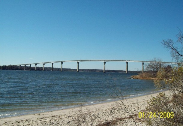
Bridge Alternative 3: A new, two-lane bridge, parallel and south of the existing Thomas Johnson Bridge. The existing bridge would be kept open to southbound traffic. The new span would carry northbound traffic, consist of two 12-foot-wide travel lanes, a four-foot-wide inside shoulder, and a 10-foot-wide outside shoulder. The bridge would have a 10-foot-wide shared-use bicycle/pedestrian path separated from the shoulder by a concrete barrier. Under this alternative, Option A would decrease the height to approximately 70-foot-high vertical clearance over the Patuxent River shipping channel. Option B maintains the existing 140-foot clearance over the Patuxent River shipping channel.
Bridge Alternative 4: a new four-lane bridge, parallel and south of the existing Thomas Johnson Bridge. Upon completion, the existing bridge would be removed. In each direction, the bridge would consist of two 12-foot-wide lanes, a four-foot-wide inside shoulder, and a 10-foot-wide outside shoulder. In addition, there would be a 10-foot-wide shared-use bicycle/pedestrian lane on the south side of the bridge, separated from the shoulder by a concrete barrier. Under this alternative, Option A would decrease the height to approximately 70-foot-high vertical clearance over the Patuxent River shipping channel. Option B maintains the existing 140-foot clearance over the Patuxent River shipping channel.
MD 4 Mainline Alternatives
St. Mary’s County: Widen MD 4 to a four-line divided roadway from Patuxent Beach Road to just beyond Patuxent Boulevard in St. Mary’s County. The typical section would consist of two 12-foot-wide travel lanes, a 10-foot-wide outside shoulder, and a four-foot-wide inside shoulder in each direction, with a 30-foot-wide open grass median. Turn lanes could be added to intersections where needed along MD 4. An optional 10-foot-wide bicycle/pedestrian path could be constructed to the south side of MD 4, separated by a 10-foot-wide grass buffer.
MD 4/MD 235 Intersection Options
Option A: Continuous Flow Intersection: Add two new signals on the north and west legs of the intersection. The three traffic signals would be used to disperse traffic through the intersection. This option takes the primary left-turning traffic at the intersection of MD 4 and MD 235 and moves it to the left of oncoming traffic, allowing left turns to be made at the same time as through movements. MD 4 would carry two through lanes in each direction, and MD 235 would maintain three through lanes in each direction. A bicycle and pedestrian path would be provided through the intersections and connect with St. Mary’s County’s proposed Three Notch Trail.
Option B: At-Grade Intersection with One-Directional Flyover takes traffic turning left from southbound MD 4 to southbound MD 235 and moves it onto a single-lane flyover ramp to bypass the MD 4/MD 235 intersection. The traffic signal would remain for all other intersection movements. A left turn lane would be provided as a redundant movement to the flyover ramp for local access to businesses. MD 4 would carry two through lanes in each direction, and MD 235 would maintain three through lanes in each direction. A bicycle and pedestrian path would be provided through the intersection and connect with St. Mary’s County’s proposed Three Notch Trail.
Option D: Single Point Urban Interchange is a grade-separated interchange, with MD 4 crossing under MD 235 below ground level. Option D keeps all through traffic on MD 235 flowing (without a traffic signal) with two lanes southbound and three lanes northbound. All left turns would be regulated at a single signalized intersection on the lower level, and would use ramps to get to and from each roadway. Through traffic along MD 4 would also cross through the signal, with two through lanes in each direction. Right turns would be made on ramps that do not pass through the signal. A bicycle and pedestrian path would be provided through the intersections and connect with St. Mary’s County’s proposed Three Notch Trail.
Calvert County: From north of the MD 4/Patuxent Point Parkway intersection to the Patuxent River crossing, several options have been developed to improve traffic operations along the Calvert County portion of MD 4. Bicyclists and pedestrians would continue to use MD 765, the service road that parallels MD 2/4.
With any of the build alternatives, the existing ramp at the base of the bridge from northbound MD 4 to Solomons Island Road will need to be relocated. These options include:
-Shifting the ramp approximately 1100 feet north and creating a “T” intersection with the parallel service road
-Shifting the ramp approximately 900 feet north and creating a four-way intersection with the service road and retail-center entrance
-Removing the right-turn access and creating a left-turn access onto the existing off-ramp from southbound MD 4 toward the Solomons Island boat launch
Additional options for access to and from the parallel service road for Solomons Island include:
-A “no change” option that maintains the access points as they exist today, with the exception of the ramp from northbound MD 4 to Solomons Island at the base of the bridge
-A “median widening” option that adds four-foot-wide shoulders to the inside of MD 4, reducing the width of the open grass median to 22 feet
-An “access control” option that consolidates the access points to and from the service road between the base of the bridge and Patuxent Point Parkway
Traffic volumes have more than doubled on MD 4 in the past decade. More than 60 percent of Calvert County residents commute outside of the county. More than 17,000 people work at NAS Patuxent River. Traffic congestion on the Thomas Johnson Memorial Bridge is a problem greatly increased during peak traffic volumes going to and from work.
Inadequate shoulder widths along the bridge cause major traffic delays both northbound and southbound as a result of accidents and maintenance activities.
The current Thomas Johnson Memorial Bridge does not provide adequate accommodations for bicycles or pedestrians.